Climate Outcome NZ
  • Climate Outcome. Home page.
  • Latest posts & news
  • Temperature
  • Precipitation changes in a warming world.
  • Increased flood damage in a warming world.
  • Drought
  • Wind
  • El Nino Southern Ocilation. ENSO.
  • Sea Level
  • Polar melting
  • Arctic sea ice + weather.
  • West Antarctica
  • Ocean Acidity
  • Plant Die Back. Animal Migration.
  • Climate threats
  • Streams a vital resource.
  • Clean energy alternatives.
  • Climate Change in the Bay of Islands
  • The Author. Bob Bingham.
  • Satellite accuracy.
  • Reference sites

Bob Bingham Blog page.

A series of opinion pieces on, mostly climate change and related subjects to do with New Zealand.

Back to home page.

El Nino on its way. Is it a big one?

31/5/2014

8 Comments

 
Information from NOAA and commented on by top USA climate scientist Kiwi Kevin Trenberth, indicate that we have a larger than normal El Nino event forming and this is a much shortened version of the forecast.
Picture
Picture
With the deployment of the Argo buoys in 2004 we now have much better information of what is happening in the oceans and it is easier to see when an El Nino is forming and to forecast its size and effect.

Picture
Of the classic early indicators we have recently had three big bursts of Westerly wind which blow in the reverse direction to the normal seasonal trade winds.

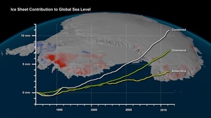
 There has also been a 100mm (4") increase in sea level in the Eastern pacific as the sea is driven up by the wind and boosted by thermal expansion as it heats up.


Picture
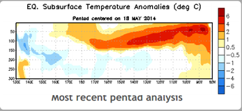
A more serious and certain indicator is the Kelvin wave which is a huge mass of warm water at a depth of 150 metres below the surface moving in an easterly direction towards Mexico and this water is 6C above normal.

During June there will be a more certain estimate of the El Niño’s size and it should start affecting our weather in December and peak in February. Classic changes to the weather would be increased hurricanes in the East Pacific around Hawaii and Tahiti with increased rains in Mexico and California, disruption of the monsoons in India and Africa and a hot and disrupted weather pattern all round the world.

 In New Zealand we may have a drought.


Picture
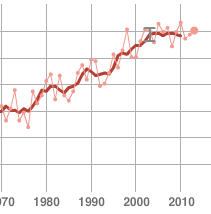
From the NASA world temperature graph you can see that 1998 was an abnormally hot year which is why the deniers say we have not had any warming for seventeen years (2010 was actually the hottest year but in the deniers world facts get in the way of good misinformation) and if we get an El Nino of equivalent strength we should get a similar temperature spike.

With the number of people who die in these big events it is not a happy forecast.


8 Comments

Rising Sea levels from melting ice.

15/5/2014

4 Comments

 
Picture
There has been research published recently showing that the glaciers in Antarctica are unstable and destined to collapse and melt away. As always the timing is uncertain and it may be a long time in the future and also the potential seven metre contribution to sea level rise seems remote. The problem for people living today is that we only need one metre of sea level rise to totally disrupt the world economy and so it is in everyone’s interest to watch for sudden changes..
There are currently two major ice masses that are unstable, one is West Antarctica and the other is Greenland. Each of them has different problems but both suffer ice loss at the same time due to temperature increases and they can each contribute seven metre rises to sea levels.


Picture
When the planet moved from the last ice age to the present warm period  around fourteen thousand years ago there was a sudden increase in sea levels which amounted to twenty metres over four hundred years or, five metres  a century or, one metre every twenty years.

Picture
The recent research on West Antarctica focuses on the Amundsen Sea and the six glaciers around Pine Island.  Observation has shown that the ice in the ice shelf has been melting from the underside at the rate of 50 mm a day
. As the ice melts it allows more warm water to circulate underneath the ice where it rests on the sea bed and the ice then floats. This point is called the grounding line and it has been retreating towards the land at up to thirty five kilometres  (twenty two miles) a year. As the ice shelf floats in the sea and thins it becomes subject to tides and storms and begins to crack and break away.  The ice shelf is around five hundred meters thick and acts as a buttress to hold back the ice in the glaciers on the land and so, with no ice shelf, the glacier starts to slip towards the sea at a much increased rate. This has already been observed with the glaciers in both Greenland and West Antarctica.

The scientists who work in Greenland and Antarctica are extremely concerned about the speed of changes in these regions and with only one metre of sea level rise needed for disaster so we be worried also .


4 Comments

Tree Die Off.

11/5/2014

3 Comments

 
Picture
Plants and Wildlife.
The last time the world had today's level of 400 part per million of CO2 was four million years ago and the trees and plants at that time were adapted to the climate that went with it. Those trees had taken thousands or years to evolve to match those conditions. The trees we have today are adapted to a CO2 level of 280 PPM and a climate 0.8C cooler than today and are rapidly going into conditions 2C warmer and with dramatical changed rainfall conditions of either drought or flood.
 We can expect to see much large numbers of trees and other plant life dying in the coming years. 

3 Comments

Ocean conveyer circulation time.

2/5/2014

4 Comments

 
Picture
The Great Ocean Conveyor is a huge mover in the worlds climate and yet we know very little about its deeper workings. 
As the Gulf stream travels from the Caribbean to the Arctic circle it cools and as it does so it soaks up vast quantities of CO2  and when the cold water disappears into the deeps it takes this CO2 with it. This CO2 load has the capability to make the sea more acidic when it eventually resurfaces  which would be very bad for phytoplankton, the base of the marine food chain, . The water going into the depths, although cold, is not as cold as it used to be and is consequently carrying heat into the depths of the ocean which is one way the oceans absorb 93% of the world’s heat.

Now this is the question. The Gulf Stream travels at 6.4 kilometres an hour and if the world has a circumference of 40,075 kilometres it would take 260 days to make a full circumnavigation. Clearly it does not do this but how long does it take? We know almost nothing about the current flow in the deep oceans even though we have a map of the thermohaline circulation flow.


NOAA states that it takes 1000 years for a full circumnavigation but I was under the impression it was only 14 years from sinking in the North Atlantic to surfacing in the Southern Ocean. That’s a huge disparity for a physical process that has a monumental effect on the temperature of the atmosphere and the acidity of the oceans.

It’s a question of how the water circulates. Does it stay as a current moving down valleys on the sea bed like a river or does it disperse and spread its heat and acidity throughout the oceans.

It’s not for the author. Bob Bingham to disagree with NOAA but I think it would be more like the faster option with the water surfacing after about twenty or thirty years bringing its heat and acidity back into circulation. Research is gathering pace and I suspect we will not have long to wait for more answers but at this stage your informed speculation is as good as anyone else
.


4 Comments

    Bob Bingham 

    Occasional blog posts on topical news items concerning the climate.  Please click the RSS feed to receive updates.

    Picture

    Archives

    January 2023
    November 2022
    June 2022
    May 2022
    May 2021
    May 2020
    April 2020
    March 2020
    September 2019
    December 2018
    April 2018
    March 2018
    January 2018
    December 2017
    September 2017
    June 2017
    April 2017
    March 2017
    February 2017
    January 2017
    December 2016
    November 2016
    October 2016
    August 2016
    July 2016
    June 2016
    May 2016
    April 2016
    March 2016
    February 2016
    January 2016
    December 2015
    November 2015
    October 2015
    September 2015
    August 2015
    July 2015
    June 2015
    May 2015
    April 2015
    February 2015
    January 2015
    December 2014
    November 2014
    October 2014
    September 2014
    August 2014
    July 2014
    June 2014
    May 2014
    April 2014
    March 2014
    February 2014
    September 2013
    May 2013
    April 2013
    March 2013

    RSS Feed

    Categories

    All
    Clean Water
    Climate Change.
    CO2 Levels
    El Nino
    Floods
    Methane
    Ocean Acidity
    Pine Island Galacier
    Sea Level Rise
    Soil Loss
    Storms

    RSS Feed

Proudly powered by Weebly